Hide + Seek Transit Game: DC Metro Area
I ran a game of Jet Lag’s Hide + Seek Transit Game with some friends in DC—or, more accurately, the DC metro area, using WMATA Metrorail. This post is a post mortem of sorts; I’ll be sketching out the play-by-play alongside thoughts on issues encountered and things to improve for next session.
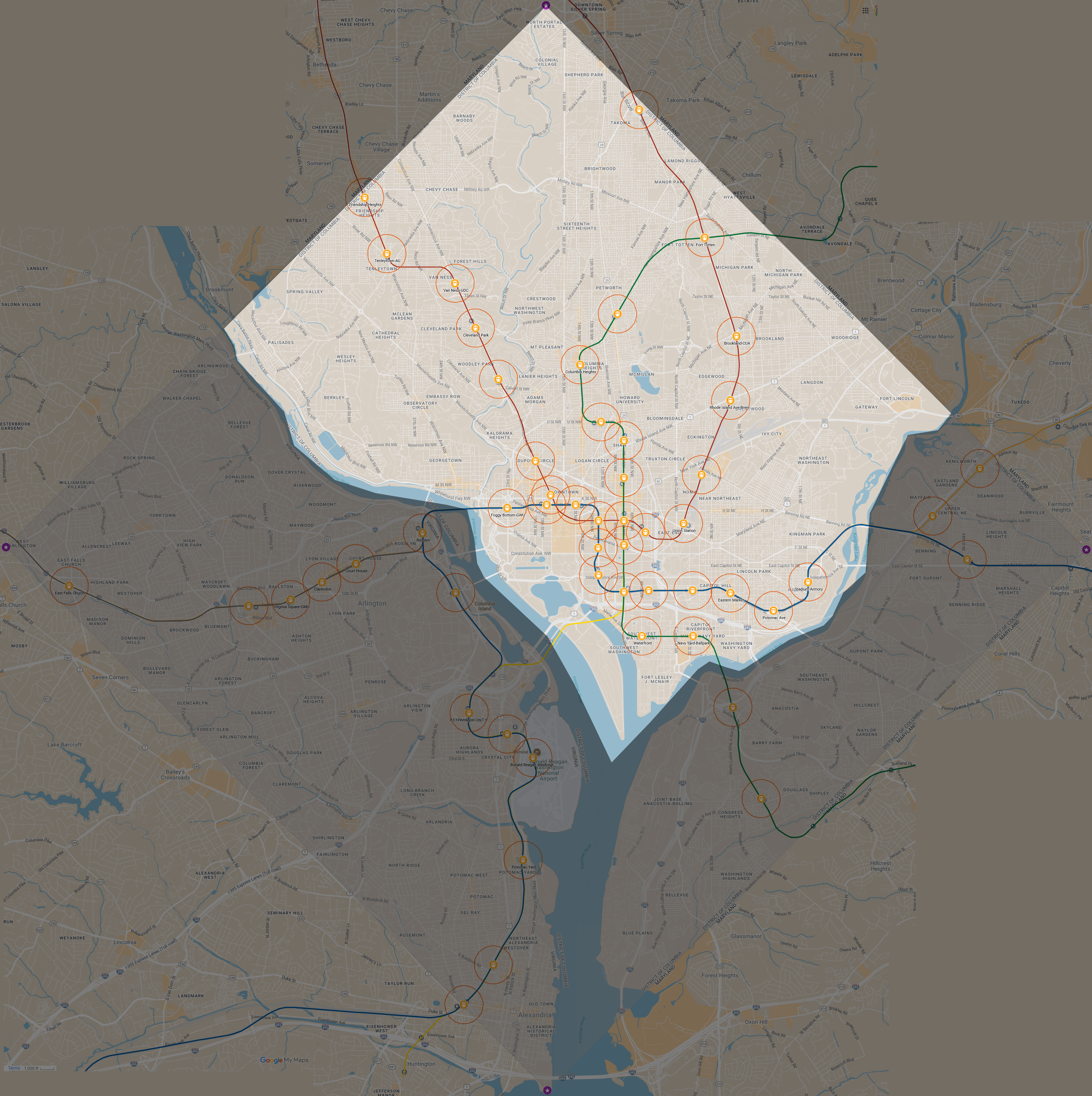
Our play area was the square formed by the original DC boundaries, encompassing all of DC as well as the portion that was retroceded to Virginia (Arlington and a portion of Alexandria). This sizing put us at a ‘small’ game size with Metrorail stations as our transit stations and hiding zones. I had considered including high-frequency Metrobus stops in order to bring Georgetown into play, but this was both too sprawling and too annoying to map given my limited ability with GIS software. We did allow players to use buses and bikeshares to get around, but this didn’t end up becoming relevant.
Oh, and, I removed the Pentagon station. For obvious reasons.
Our starting location was Metro Center, since it’s central and gives lots of options. At a small game you get 30 minutes to hide and from Metro Center you can get on BOS or R, or walk a few blocks to Chinatown for access to GY. There were two stations (Brookland and Fort Totten) closed for maintenance, but they were on the northeast portion of the Red Line and the Green Line would take you to Fort Totten still), with free shuttles replacing the service up to Takoma. We figured it was unlikely anyone would use that, given the difficulty of timing shuttles, but kept it in play for fun.
Since we had a few people that weren’t certain if they could make it or not, we met at 10:00 and formed teams day-of. Not everyone had watched the show, so this also served as an opportunity to go over rules and clarify points of contention. We ended up with 7 total players and split into teams of 3 and 4. There was some consideration for a 3/2/2 split, but given this was the first game we were running and the fact that most of our players lived in Virginia and might not be as familiar with DC stations, we erred on the side of larger groups to keep things flowing and make sure nobody felt too lonely/unsafe/bored. We also wanted to make sure we finished before the sun set, so fewer teams felt better (although even given that we ended up finishing at ~18:15 or so)
WMATA has signal repeaters underground and cell signal throughout the area is generally good, so we used Discord for communication and Google Maps for location sharing. This ended up being a bit flaky, so halfway through the first hide we had a second seeker also share location with iOS and repeated this for the second hiding session. Highly recommend redundant location shares.
Round 1
After all the setup, we began the 30 minute hiding period at 11:55, with the team of 4 hiding first. At 11:26, the seekers (team of 3, including myself) asked our first question: Matching - Nearest Landmass (with the agreement that the possible landmasses were west of the Potomac, east of the Anacostia, and in between). This turned back a “yes”, so we knew they were somewhere in DC proper
I should note also that all of these diagrams are being drawn after the fact. The day of, my team was using a combination of the built-in ruler in google maps and some paper maps with a compass and straightedge. The opposing team also had paper maps but were mostly free-handing it, I believe, as well as with the maps ruler.
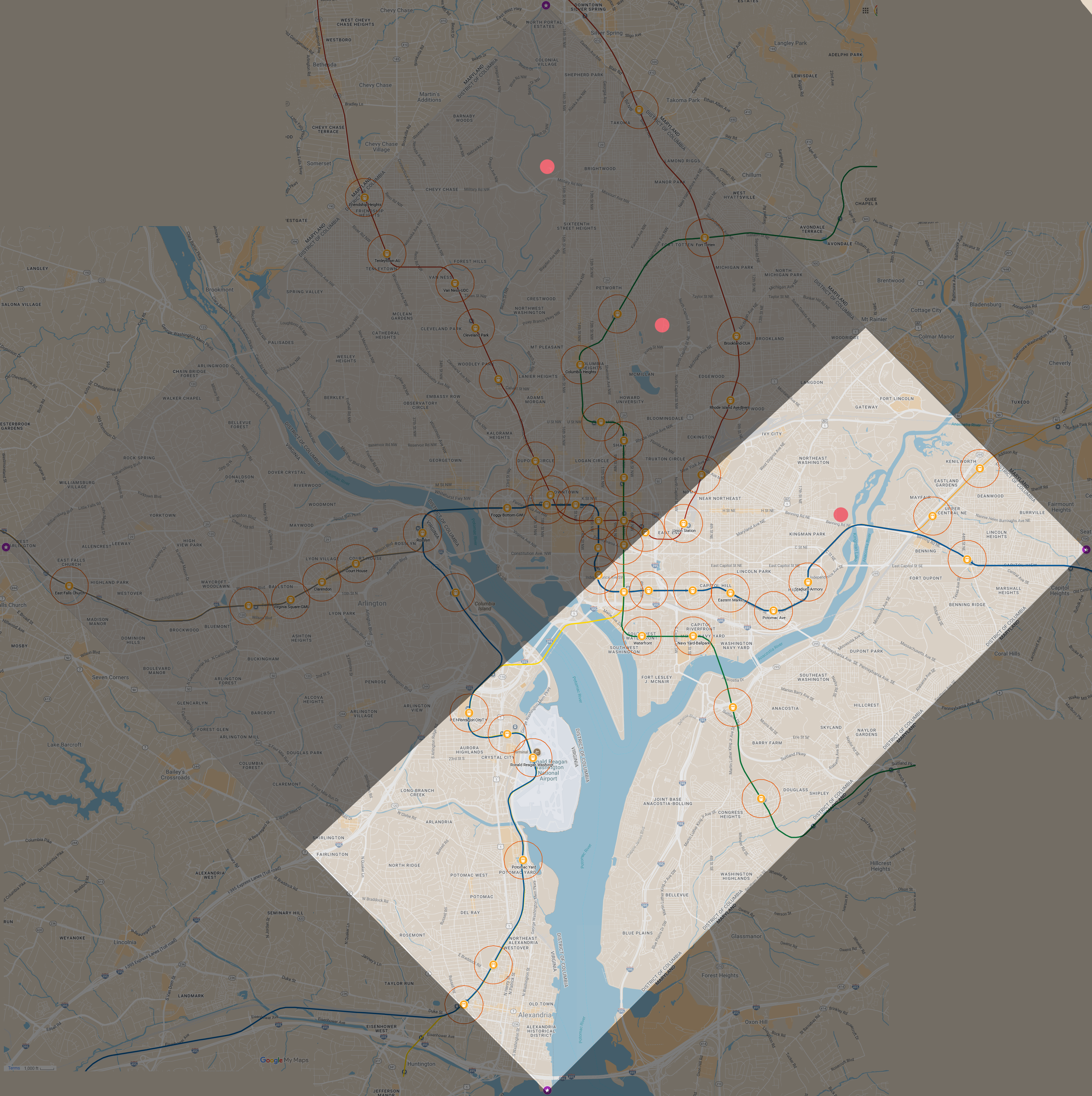
From Metro Center, they could reach pretty much anywhere in this zone with the exception of Takoma (we were pretty sure the timing didn’t line up to catch the shuttle, since they would have also had to run to Chinatown to get the Green line up Fort Totten, an already fairly tight prospect for 30 minutes.) We needed to cut this down, and try and eliminate either the Red Line stations or the Capitol Hill/Waterfront areas. We figured the best options for this were Measuring (Hospital), Measuring (Rail Station), Radar (1 mile), or Thermometer (1/2 mile). The measuring options largely looked good, but required us to position carefully and potentially left some holes on the red line, and Radar was awkward given the density of downtown stations, so in the end we settled on a 1/4 mile Thermometer for a North/South split. This was easy enough from Metro Center, we just went two stops south to Smithsonian and got a “hotter” for our efforts at 11:45
This is pretty good, though does leave a good chunk of the downtown core in play alongside the Blue and Green Line outskirts. When deciding on the thermometer, we knew we would want to narrow things down and figured a photo question would be the best bet, and were leaning on either widest road or tallest building depending on which way the Thermometer returned. With it knocking out a lot of red line and downtown, we decided to go for Photo of Widest Road, cognizant this would also give the hiders their third hard and make it pretty likely they had a curse to deploy (in fact, with two, it was very possible they had a curse.) As such, just a few minutes later at 11:47 we ran out the question and decided to head onwards to the more central location of L’Enfant to wait.
This was our photo response, and this ended up being the problem point for the first round, though we of course wouldn’t find out until later. I had emphasized during setup that the “Tallest Building From Your Sightline” question was manipulatable—as long as it wasn’t endgame, hiders could walk around to try and get a tight angle on a building to minimize information. Unfortunately, the hiders thought this extended to the other photo questions, including the Widest Road, meaning they thought it meant the widest street closest to them currently and took a photo of the widest road from where they were currently standing. On the other hand, we as seekers understood it to be “the widest road in your hiding zone”.
This is something very important to note. Make sure seeker questions are as unambiguous as possible. It’s a massive feels-bad if a misunderstanding leads to a huge extension in time, or forces a hider to leak information in asking clarifying questions.
If it’s matching or measuring, provide GPS pins to the expected locations; if it’s a thermometer, clearly define start and stop positions and inform the hiders once your distance is up; for photos, make sure both sides know what it means. Photos especially need to be made clear that anything that is objective (e.g “widest”) must be satisfied unless the hiders cannot due to endgame. Later, we also ruled that we would only consider a road valid for this question if it had a sidewalk, meaning most highways did not count but some (like Richmond Highway) were valid. Generally, the onus will be on the Seekers to make their question crystal clear, but both parties should try and make sure they have the same understanding.
Anyways, this photo obviously looks like a pretty narrow two-lane road, though we did note a hint of brick pathing in the fore and background of the image that we initially thought was dirt. Based on satellite imagery, we figured our best option for such a spot was going to be Stadium-Armory or possibly Waterfront, and eliminated most of the other Blue Line stations due to having much wider roads. We start heading in that direction, deciding to drop a 1 mile Radar at Potomac Ave to try and bisect the Blue vs Green Line options (the radius includes Stadium-Armory and Eastern Market, but not Waterfront or Navy Yard, and saves our 1/4 mile Radar for later.)
Unfortunately, we get hit with a Randomize Question at 12:10 that turns it into a 3 mile radar instead, returning at 12:17 with a “yes” and giving us zero information. However, we guessed that the Randomize was used defensively and the radar would have hit (from a strategy standpoint, I think Randomizes should be used as cantrips and run out immediately to minimize information leakage and potentially throw off the seekers, but I digress) so we assumed they were in Stadium-Armory. Potomac Ave and Eastern Market were the other stations that would have been within 1 mile, but as mentioned previously we thought their streets were too wide based on street view.
At the same time, they also hit us with Curse of the Lemon Phylactery. Potomac Ave and Stadium-Armory looked barren of grocery stores based on the map, so we had to turn back towards Eastern Market to buy lemons from a nearby Trader Joe’s, knowing that we would definitely need additional questions to narrow things down in the endgame.
This was the second big issue: Lemon Phylactery requires a powerup to be discarded as a cost, but the hiders did not understand the card types and thought Time Bonuses counted. I didn’t realize this until we were already on the train, and we texted them for clarification on if they were still able to use it, but decided to pick up lemons preemptively anyways. At 12:30 they hit us with a Curse of the Ransom Note and confirm they are not able to use Lemon Phylactery.
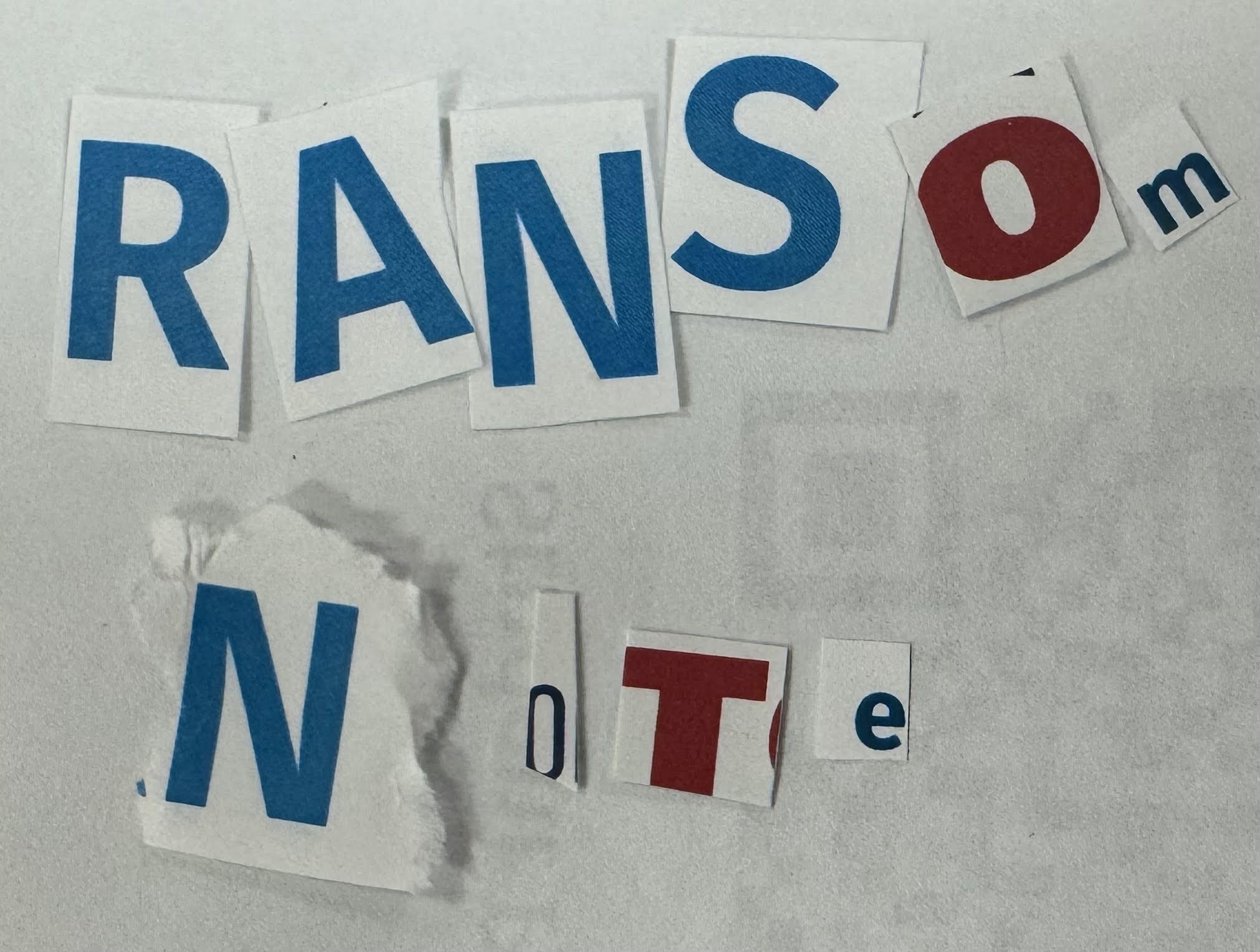
Hiders/Seekers should take care to always be monitoring their comms, the delay in response here burned a fair chunk of time for us and was likely because they were all distracted putting together their ransom note. As a secondary note, hiders should always send a picture of the curse card’s full text to reduce ambiguity, since the rulebook doesn’t contain full text. I also suggest including a picture of any cards you are discarding as a cost, since this helps catch issues like this (it’s how we caught it, the seekers showed us both cards)
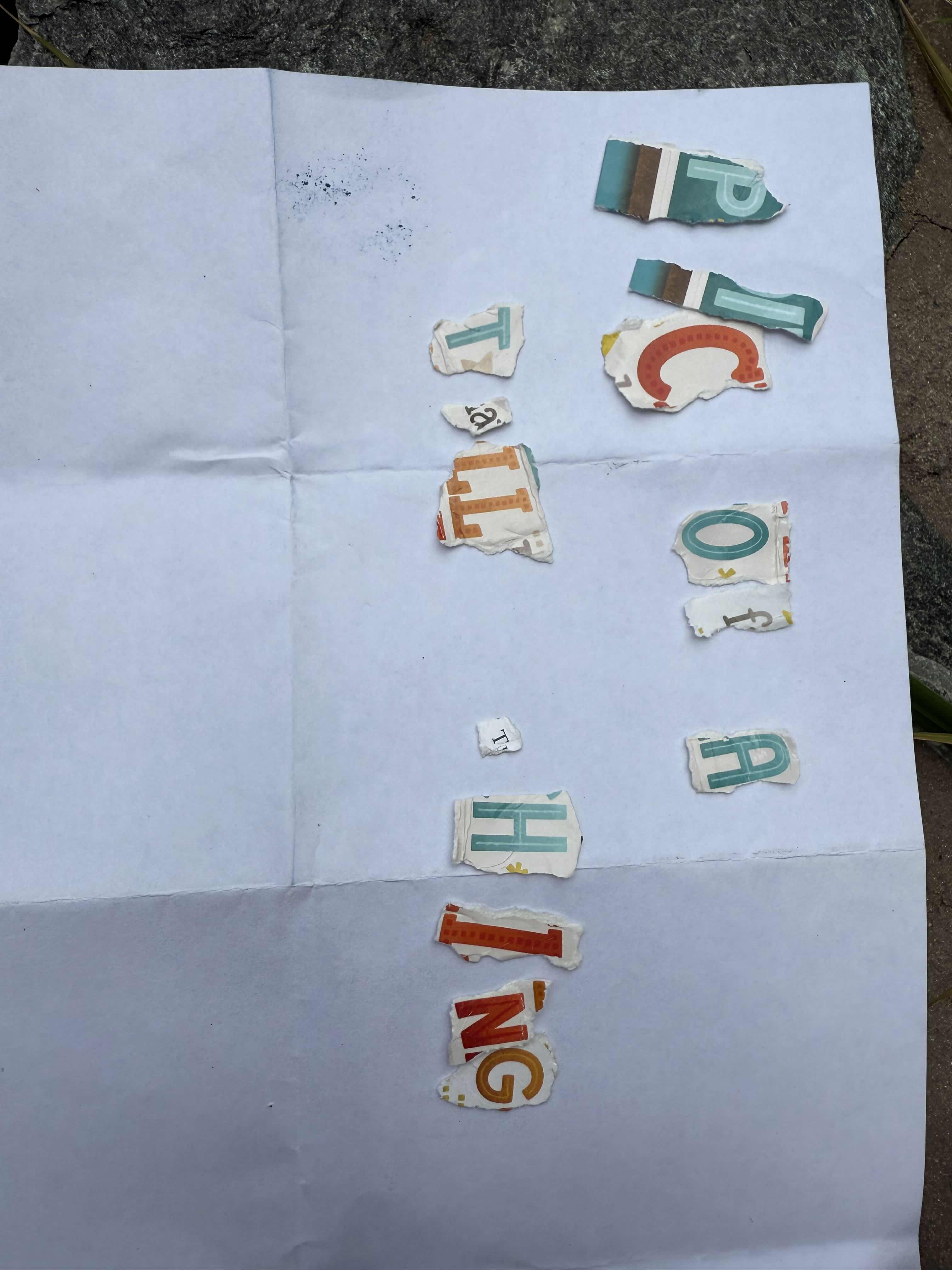
That was less than ideal, but we couldn’t do too much about it now. Later, we agreed to count it as a 10 minute penalty, which is fair enough given that we would have had to head that direction for the ransom note materials anyways. Either way, we grabbed the lemons and a greeting card from Trader Joe’s and headed back to Stadium-Armory. It’s worth noting that endgame only begins once the seekers are in the zone and not on transit, and being in the station counts as being ‘on transit’, so it may be useful for seekers to announce on comms every time they are exiting a station to reduce ambiguity, especially if GPS is flaky. With Ransom Note in effect, we found a nearby bench to put together our question: “PIC OF A TALL THING” (Photo of Tallest Structure in Your Current Sightline)
While we wait for an answer, we walk around trying to identify the crosswalk they sent. 10 minutes later, at 13:07, we get our response (as an aside, the hiders stalled the full 5/10m time period for every question. I’m mixed on how I feel about this. On one hand, it’s part of the rules and strategy, on the other it’s kind of irritating and feels vaguely unsportsmanlike, at least for the non-photo questions where you should be able to answer objectively quickly enough)
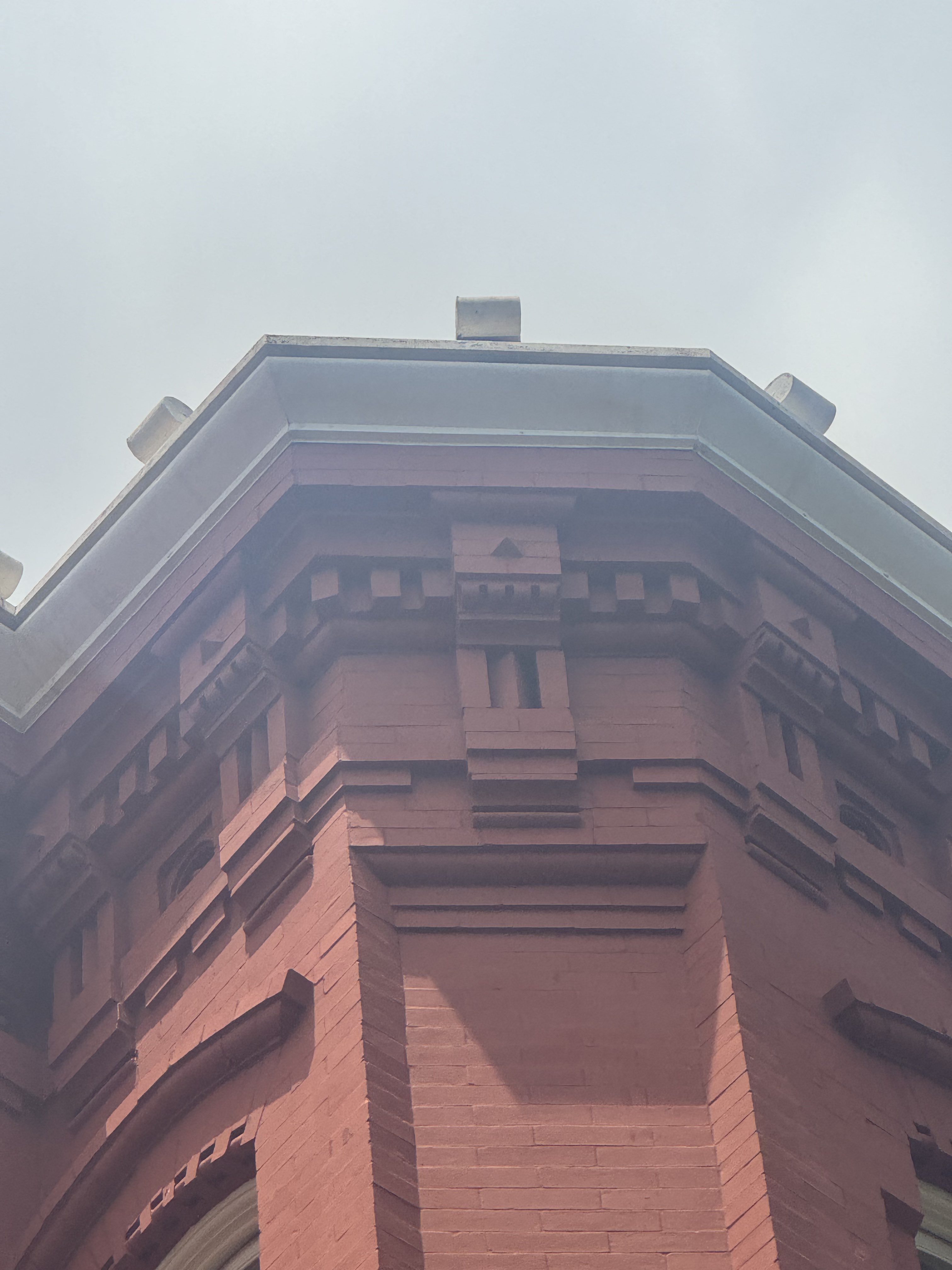
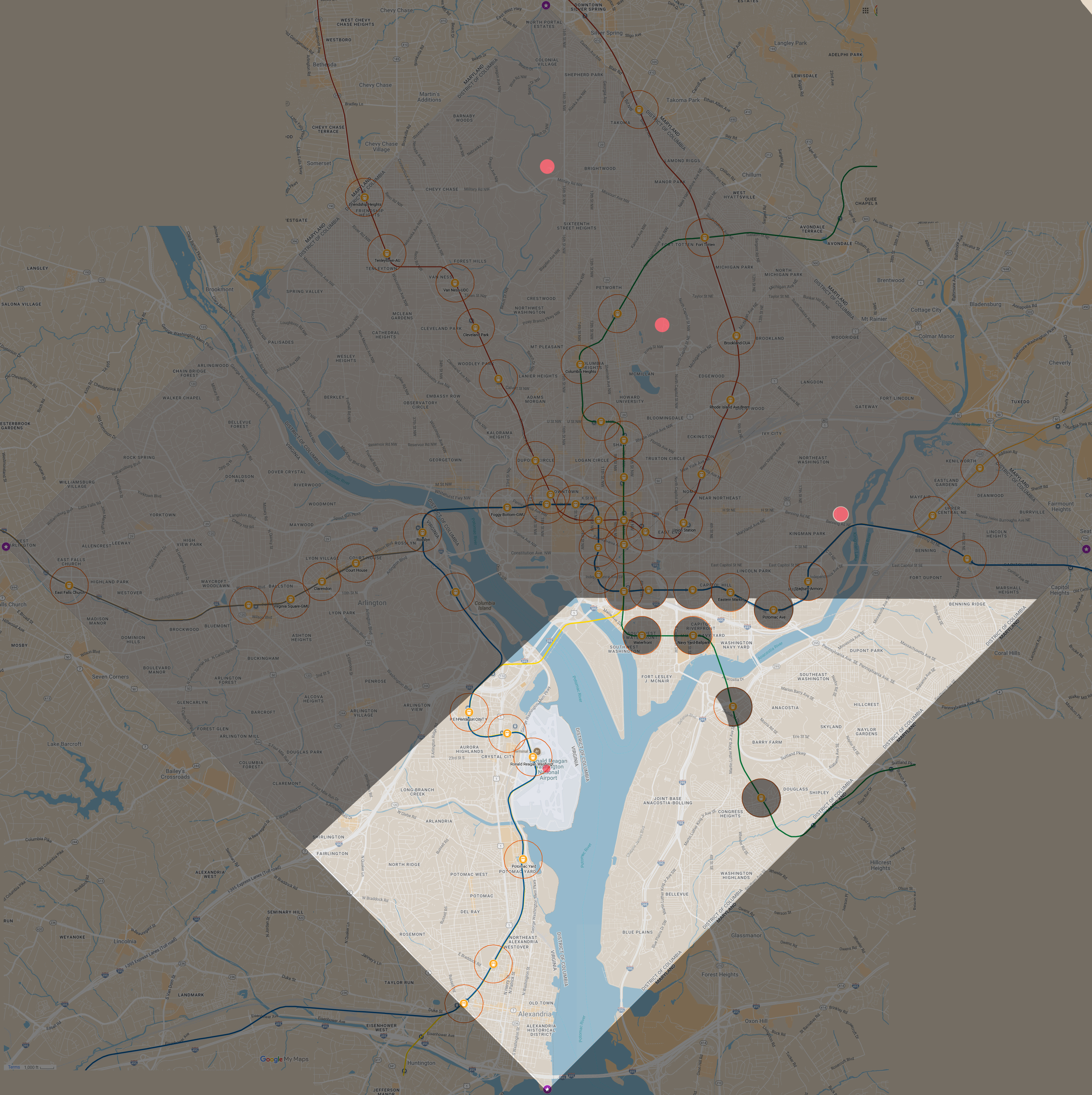
This is when we start getting a bit suspicious—two of us immediately recognize it as looking extremely like the architecture in Eastern Market, and not very characteristic of the Stadium-Armory area. Also, we expected them to be in Stadium-Armory meaning endgame rules would be in effect, so they would have to be hiding outside for them to be able to send a non-null photo. Still, nothing to be done, so we walk around for awhile searching for the skyline. Eventually we end up in a small park southeast of the center point having not seen anything, and at 13:17 decide to throw out a 1/4 mile Radar to try and bisect the space. This returns “no” at 13:22, eliminating most of Stadium-Armory and a small chunk of Potomac Ave. The remainder of Stadium-Armory is just a bit on the northwest side, since the east bit near the actual armory building has basically nothing.

They hit us with a Curse of the Right Turn in response shortly after posting their response. We have another minor dispute at this point, with hiders having interpreted the card as forcing the hiders to always make a right turn, effectively turning the card into a 2-card 20 minute time bonus as it would force you to circle the block endlessly. This is definitely wrong given how they played it in New York, so we keep walking and we eventually dig up the citation and argue our side, but it does burn a bit of time. Still, the card is not written as unambiguously as it should be so we don’t end up levying a penalty or pause for the dispute, but it’s another example of making sure everyone is super clear on what things mean. In hindsight, we should have just paused and hashed it out.
At this point we’re thinking Stadium-Armory is extremely unlikely, but make our way back to the station while checking out a few areas to look for the building. We figure an easy confirmation will be to ask for a Photo of Building Visible from Station while standing so that we can see both station entrances, it will either null out or we’ll be able to easily narrow down their hiding spot based on the angle. We fire this at 13:35 but the seekers for whatever reason don’t see this question until 13:47, when we follow up at the 10 minute mark. The game rules provide a way to handle this, no card for the question and a pause on the game clock until the picture is provided, but this is another emphasis for both teams to be very cognizant of incoming messages to keep things flowing smoothly. Anyways, they respond at 13:53 for a total penalty of 8 minutes, sending us this photo
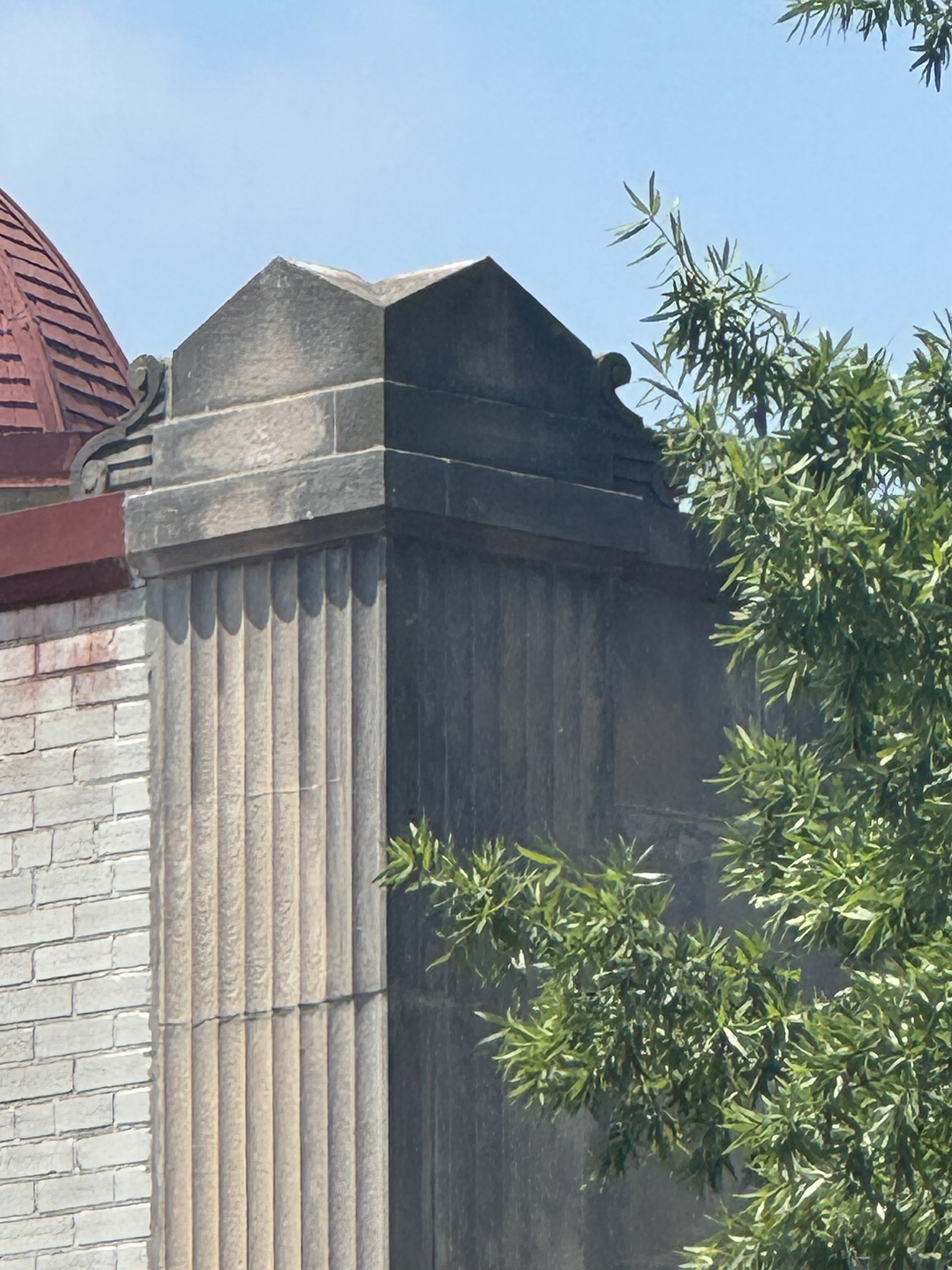
Once again we all flag this as looking extremely Eastern Market-y and this is when we finally ask for clarification on widest road and realize they had interpreted it as “the closest widest street”. This is kind of a disaster, but we at least know where they are with a pretty high degree of confidence, so we head towards Eastern Market. In the meantime, they shoot us an actual picture of their widest road at 14:09, which confirms it.
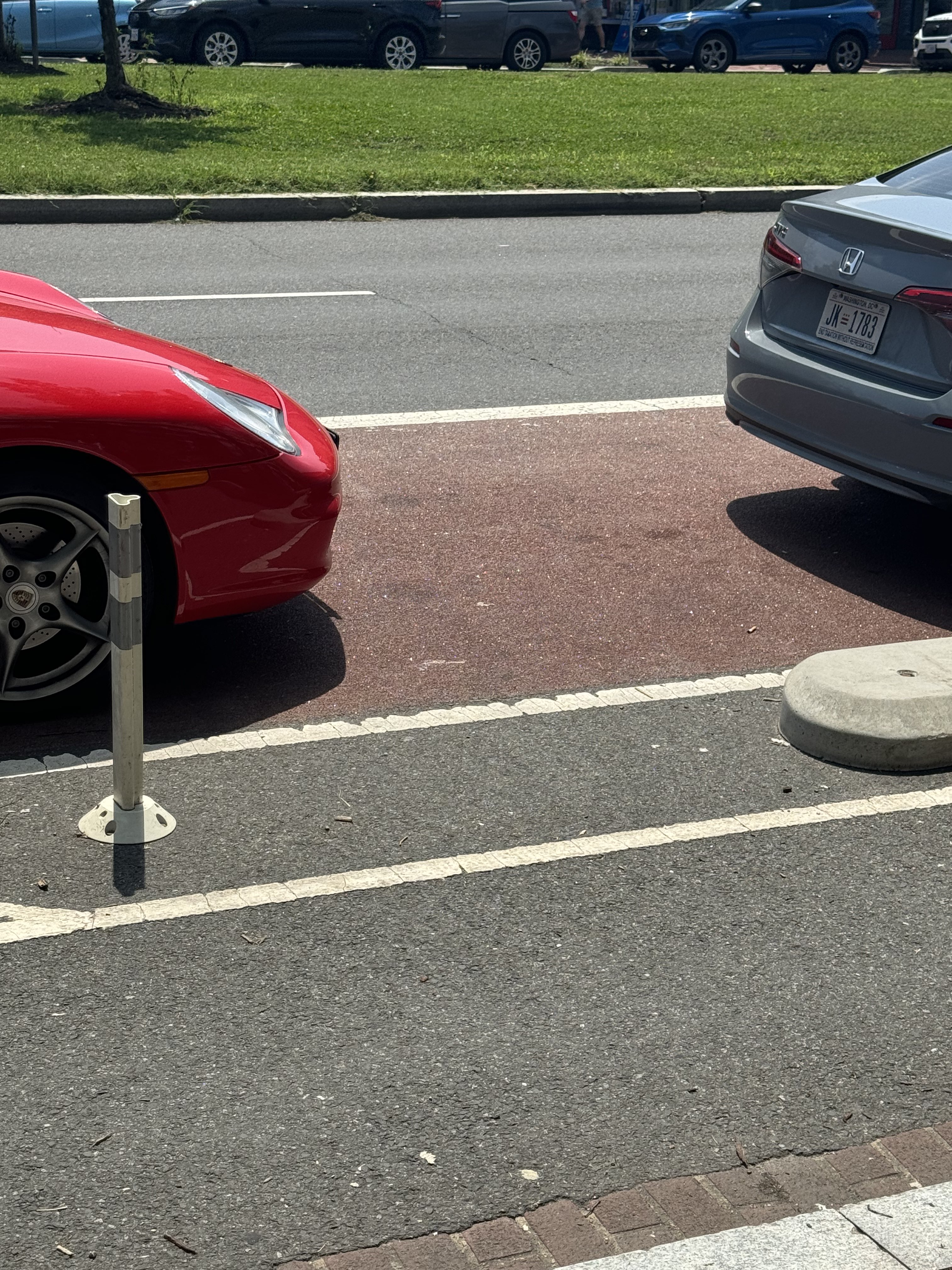
This did raise a minor point, one of the other things we clarified later regarding the road questions. Are divided roads one or two roads? Is the width the sum of the roads or the total distance including the divider? We settled on yes, it’s one road, and the total distance. Accordingly, this photo was fine, although whether or not the opposite side of the road is visible is slightly debatable. You can see the cards and the parking dividers, as well as some of the sidewalk, but can you see the road or curb itself?
Either way, it doesn’t actually matter, since we’re pretty sure we know where and in what direction they are, and quickly spot the blue car to confirm. Turns out they’re in a nearby restaurant because some of the hiders were hungry, but the service was too slow and they got stuck and couldn’t re-hide in their original spot before we triggered endgame. Their original spot was quite nasty, in an external stairwell leading downwards attached to a church. I think we would have eventually figured it out through a sky photo question and some careful measure/distance questions, but it certainly would have been annoying.
Their final time, minus the 10m penalty for Lemon and 8m penalty for the photo question, was 2h25m (not including 30m hiding period.)
Round 2
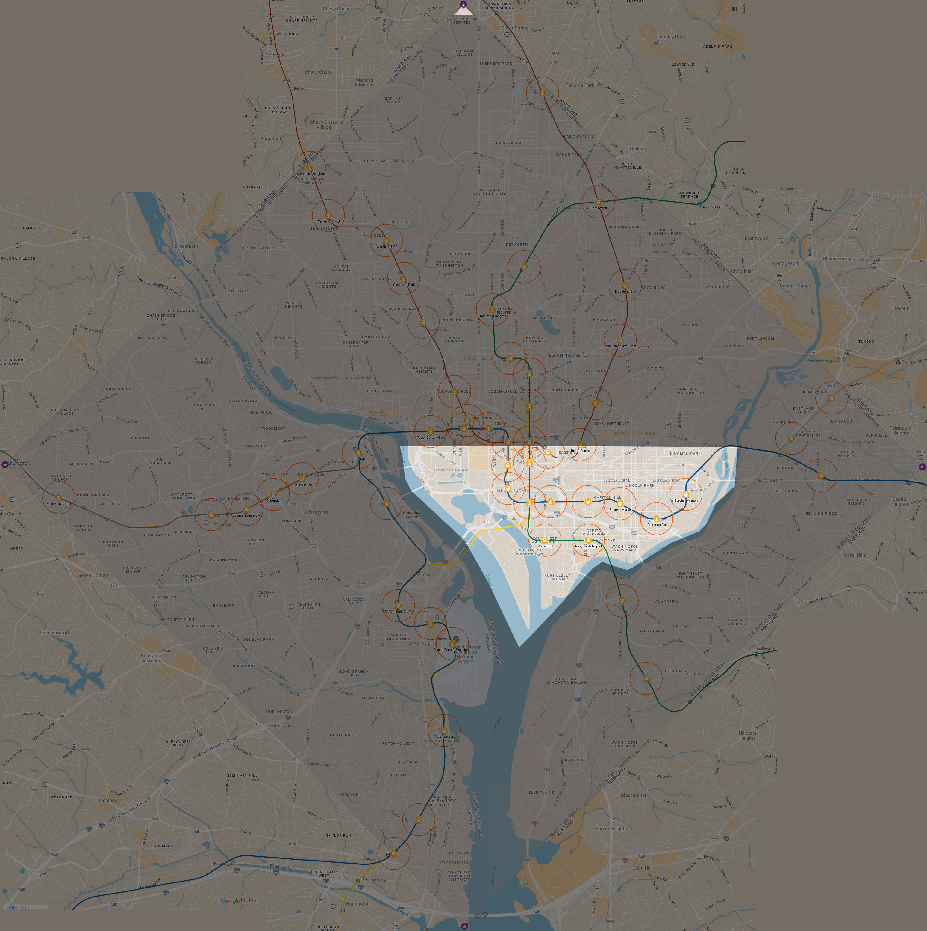
We take a break for lunch after this and swap materials, and my team, the new hiders, take our 10 minutes to discuss strategy. We figure we want to get out of the DC landmass for sure, and the question is whether we risk Anacostia (unintuitive, but has bad hiding spots in the zone) or try and leg it to the Virginia portion of the Blue Line, considering the airport and Potomac Yard.
We end up settling on Potomac Yard because of the long mezzanine and a park behind the station that requires you to take a non-obvious elevator to the rear entrance of the station. Our hiding period begins at 15:05 and we leg it, getting lucky on a transfer at L’Enfant and make it to the station at 15:30. Honestly, we had time to make it further south to Braddock Road and considered it, but none of us knew the area and the hiding options looked worse. We head to Target to rest for a bit in air conditioning and use the bathrooms.
Our seekers open up with an interesting question at 15:36: Is your closest golf course the same as ours (Langston). Off this question we draw and keep a Curse of the Lemon Phylactery. We have another small dispute, their map is showing 3 outdoor golf courses, all in DC, but ours includes two additional country clubs in Virginia. If we go by their 3, the answer is “yes”, and otherwise “no”. We’re a little scared to ask to clarify in fear of leaking information, especially since we already answered “no” before they list out the three golf courses they’re looking at (Langston, Old Soldiers’, Rock Creek), so we switch our answer to “yes” without arguing. This relates to my bit about clarification earlier: seekers should make it clear what positions they are considering and see from their map. The enumerated list helps, but you should just provide maps links/pins. I’m not sure why we saw different results, maybe the solution is checking on multiple people’s phones.
Anyways, this is what we’ve got. Note that this is an extremely rough map, since I’m recreating it digitally and don’t know how to replicate a compass in Krita, so it’s free-hand and approximate. Still, it gives a good idea of what things look like, and it’s a surprisingly good question that bisects the map (given the assumption that those were the three golf courses)
They’re then idle for awhile, during which we explore and check out that park area we spotted earlier. It turns out it’s an elevator down to the back of the station and a path that runs parallel to the platform for a bit, before hitting a small playground and a trailhead into some wetlands. This is fantastic, not only might they not realize the entrance even exists but it’s a good 10 or 15 minute hike just to get there. The only downside is that it puts us far from the widest road and makes us inflexible for other photo questions too, so we decide instead to hang out by the elevators and only run to the trail when the seekers are closing in.
At 16:11 they start a 1/2 mile Thermometer from L’Enfant Plaza heading north to Archives, which returns “colder”. Honestly, a really confusing question that doesn’t cut off as much as it should, and I learn later that they also realized they should have headed down to Waterfront and went to L’Enfant for a thermometer instead, or, since that would be at an angle, done an east/west one instead. Either way, this is what we think the hiders are now seeing for their options:

Notably, they have eliminated the outskirts all the stations past the BOS fork, which they told me later was one of their objectives, but they leave a significant portion of the Capitol Hill area stations in play, as well as the southern Green Line stations and the southern Virginia Blue/Yellow Line trunk where we are. This question also gives us the Powerup card (Discard 1, Draw 2) we need for Lemon, which we set aside for later.
They follow up the thermometer at 16:23 with a Matching Transit Line question while on the Orange headed east to New Carrolton. We answer “no”, knocking out said Capitol Hill are stations and narrowing it down to either the Green Line or Blue/Yellow Line, and draw a decent 8 minute Time Bonus.

Shortly after, I’m sure coming to the same conclusion, they follow up with the same Matching - Nearest Landmass question we led with at 16:27. This returns “no”, eliminating Waterfront and Navy Yard leaving only the BY trunk and the Green Line stations past the Anacostia.
At 16:34, we deploy a Curse of the Overflowing Chalice we got off the Landmass question pitching our Time Bonus, which lets us look at an additional card for the next 3 questions. We were on the fence for this for a bit, since 8 minutes felt a good chunk, but figure they’re likely to ask at least 2 more questions to narrow us down, and very easily 3 if we can get off a good Lemon Phylactery.
At 16:39 they run out a Measure - Airport while at L’Enfant. The only one in the game zone is DCA, and they’re about 2.5 miles away, so we end up being closer. This was another ambiguous point we realized later, we were measuring to the center of the maps location for the airport, but they were measuring to the metro station. It didn’t make a difference here, but it could definitely have, since our answer left a portion of Anacostia in play (though it eliminated Congress Heights, mostly confirming the BY trunk for the seekers)
Thanks to the Chalice, this also draws us into a Curse of the Water Weight. Between this and Lemon, this gives us two strong defensive curses which we can deploy at very awkward spots along the Blue Line to force them to get off or backtrack. We’ve definitely gotten pretty lucky with curses here, but they’ve also given us quite a few cards. We realize that Water Weight’s casting cost is also quite restrictive, 1000ft from water is not very far, so we start refreshing the trackers like crazy to try and catch them with it as they cross the Potomac (either on the Yellow Line or the Blue, depending on which train they catch)
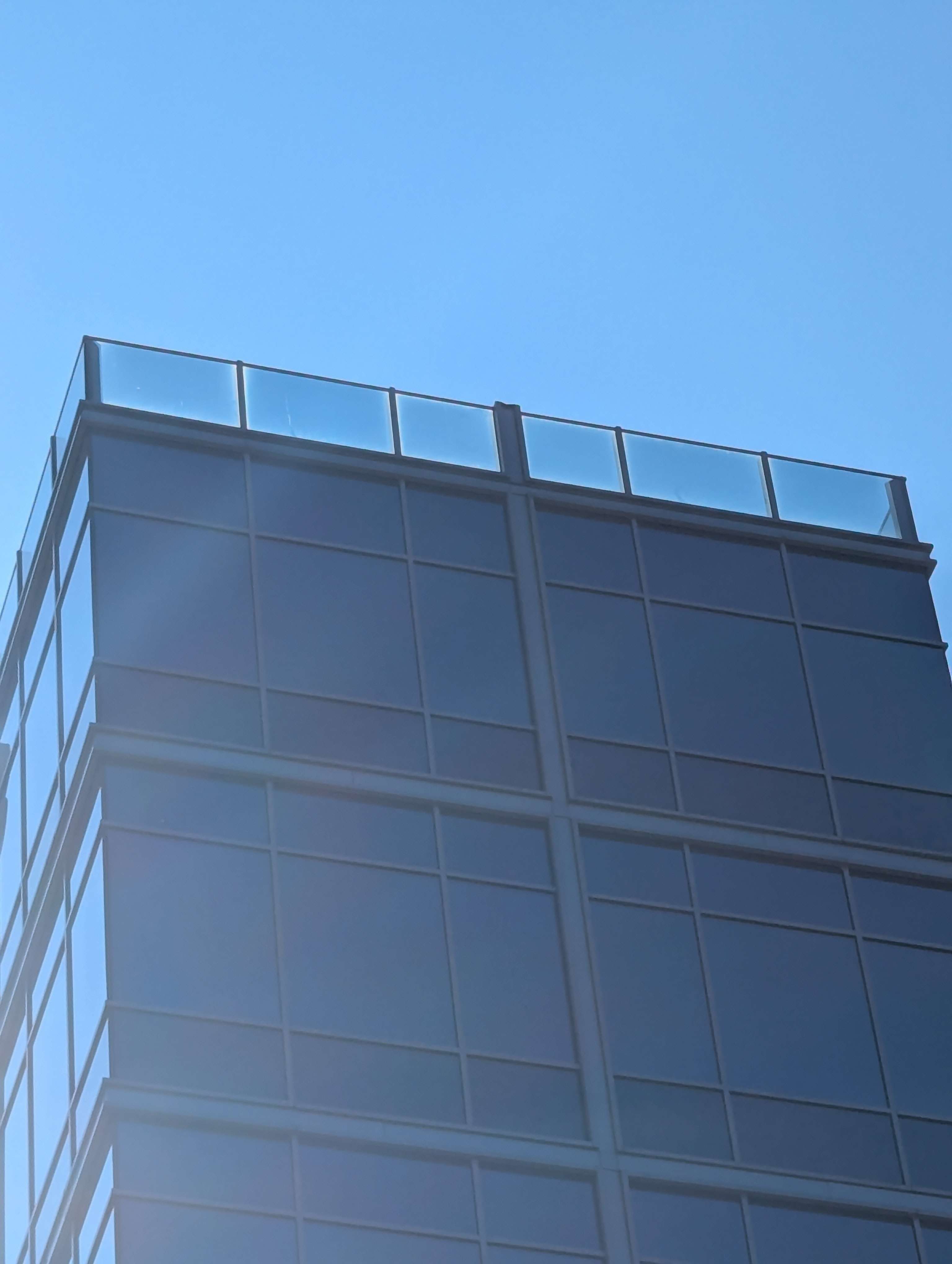
While we’re doing that, they hit us with a Photo of Building Visible from Station Entrance at 16:51, so we have to trek all the way back to the entrance. This isn’t ideal, but we end up taking a picture of a modern glass building that has been popular in the area, and we hope it might also plausibly be in Crystal City or Pentagon City. We also hope it’ll push them towards the west side of the station, rather than the east rear entrance we are hiding by, but this picture confirms Potomac Yard for them.
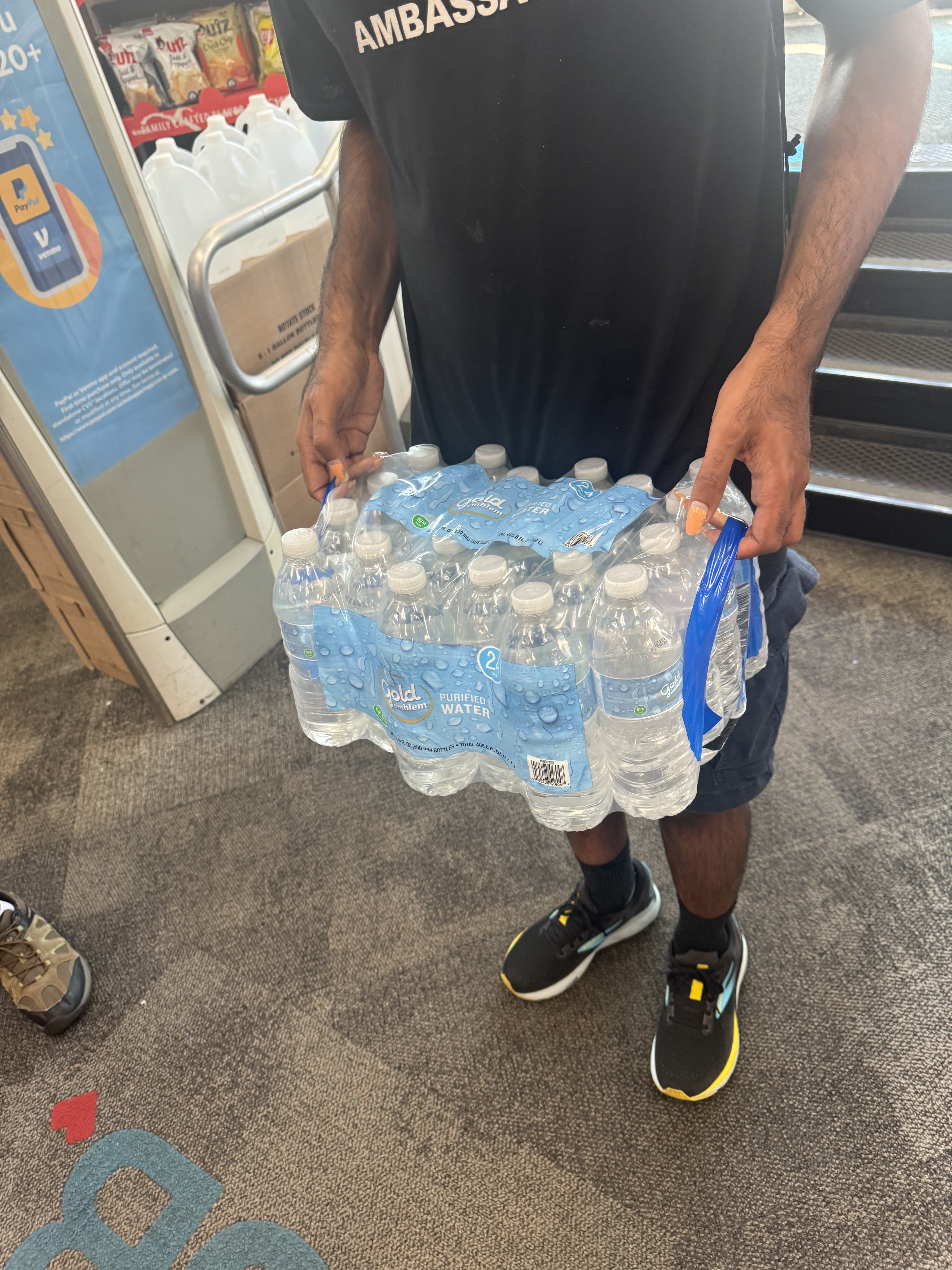
Fortunately we catch them with the Curse of the Water Weight as they cross the river on the Yellow at 16:57, forcing them to get off at Pentagon City and burn a bunch of time finding a whopping 8 liters of water to carry. Another note—this is a quite a bit, and we think in the future we will either cap the amount of curses like this or cap the cost/budget. They end up buying a whole case, thankfully on sale.
Then, as we see their trackers indicate they’ve left the station at 17:26 we hit them with the Curse of the Lemon Phylactery hoping this forces them to get off at Crystal City to search or backtrack to Pentagon City. Their trackers are acting up and not very precise at this point, and we’re not sure where they are, so we follow up with a Curse of the Zoologist at 17:32 with a picture of a bunch of ants to be safe. A few minutes later at 17:34 they enter Crystal City and end up finding a rollipolli right outside the station to knock out that particular curse.
Lemon burns quite a bit of their time, but at around 17:45 we see they are moving again south. We start walking towards the trail, keeping an eye on the trackers, and once they pass the DCA station without stopping we start sprinting towards the park and trail, hoping to at least get out of view from the platform before they finally enter the zone at 17:52 and trigger endgame.
Since their time was 2h25m we only have to hold out until 18:05. We’re fresh out of cards though, so at this point it’s just sitting tight, refreshing the tracker, and hoping they go the wrong way out of the station… which they do! We watch them head towards the strip mall and amble around for awhile, and eventually they run out a Photo of Tallest Visible Building right at 18:05. At first, we’re not even sure we can see a building, but one of my fellow hiders realizes you can juuuuuust barely make out a building through the trees
Either way, that’s time, and for good measure that photo question draws us into a Time Bonus to cinch things (I think it was 4 minutes?) We start the trek out of the mosquito ridden swamp back to the station to meet the others. It’s been humid as hell all day so we’re all happy to get out of there and into a nice air conditioned car on the ride back home.
Wrapup
Overall, everyone had a lot of fun and generally enjoyed the game. Enough that they’re interested in me running another game, anyways. That being said, I have a lot of thoughts about what went well and what didn’t. The big ones I touched on during the play-by-play, but I’ll summarize and add some more here:
- We allowed for Metrobus to get around, but 30 minutes is not enough hiding time to really utilize a bus. It lets you get around to most of the area though, especially with interlining in the core increasing frequency, so I don’t think I’m going to change this, but I encourage others to adjust your hiding period time to better suit your transit network and frequency. The provided S/M/L can be a bit loose
- Communication communication communication! Bad communication and ambiguity is what messed up the other team’s hiding round, and also caused us some issues in ours. Don’t hesitate to pause and figure stuff out!
- Drop GPS pins for everything! This especially helps for measuring and matching questions. Seekers or hiders can also explicitly provide the distances they are using (e.g for the airport question, say “I see you as 2.5 miles from the airport, using this pin. I am closer”
- A lot of questions could use clarification in advance. I talked at length about what “widest street” counts, and we settled on anything with a sidewalk, but you should also consider what exactly a “station entrance” means for the photo question (do elevator shafts count? Can you walk around the entrance?), or the transit matching (does direction matter? what about forking?)
- Curses and Powerups drawn mostly felt fine, though 8 liters for Water Weight felt overly punitive. As I mentioned above, we’re considering capping some of those curses or setting a budget limit. And then maybe once you hit your limit, if you get another curse that requires you to purchase something, you just have to take a picture of where you could buy it and then move on
- Speaking of Water Weight, 1000ft is actually really small. Given DC’s lack of lakes and ponds, I might extend this radius or cut the card entirely
- The smallest Time Bonus, 2 minutes, felt basically useless. I know they’re supposed to be filler but a blank card is just not fun. These are on my radar to potentially adjust, depending on how future games go
- All our players got to the meeting point at about 10:10 and we ended (met back up at the station) at around 18:20, so a total playtime of 8 hours and change, including a ~30m lunch break. A second game would go smoother, but not necessarily faster, given that the first team’s hiding was somewhat prematurely ended. As such, we’re considering splitting it across multiple days and giving each time an evening to plan/prep, or limiting the area to just DC between the two rivers to make sure we end at an appropriate time
- I really wish the rules were a PDF for greater searchability. I might transcribe it before our next game if I truly hate myself
- Similarly, I definitely want to write out a Curse index with full card text for the hiders especially to reference. The rulebook includes rulings on Curses, but not actually the full Curse text.
- Doubling up on tracking, especially across both google maps and iOS, was extremely helpful in flaky GPS areas. Highly recommend this.
- Paper maps and pencils alongside straightedges and compasses were a lot of fun, though I don’t know how much the other team used theirs. I need to get a cheap compass to loan out to the other team too, since I expect most people ditched theirs after middle school geometry and never thought about them again. Still, I think manual figuring is way more fun than using an app that can perfectly calculate the possible area for you
- I still kind of want to see about high-frequency Metrobus stations and Georgetown, but this area felt large enough that that’s not necessary. Also, I need to get better at GIS software before doing that. The main takeaway here is to lean on keeping it simple, since unless you’re already familiar with it using GIS software is a massive pain in the ass.
- However, I was able to download datasets from various online repositories, mostly governments, that populated all the Metrorail lines and stations for me! Unfortunately, I had to do the hiding zone radii by hand, but that still saved me a ton of time (and the fact that there is not an equivalent for just the high-frequency Metrobus stations is a big reason I haven’t done it.) Most of them were from https://catalog.data.gov, for reference.