Hide + Seek Transit Game: DC Metro Area - Take Two!
This past weekend I ran our second game of Jet Lag’s Hide + Seek Transit Game with some friends in the DC metro area, using WMATA Metrorail (you can find the first game’s writeup here. This post is a play-by-play and a post mortem of sorts, I’ll talk through the game and how well the changes we made went.
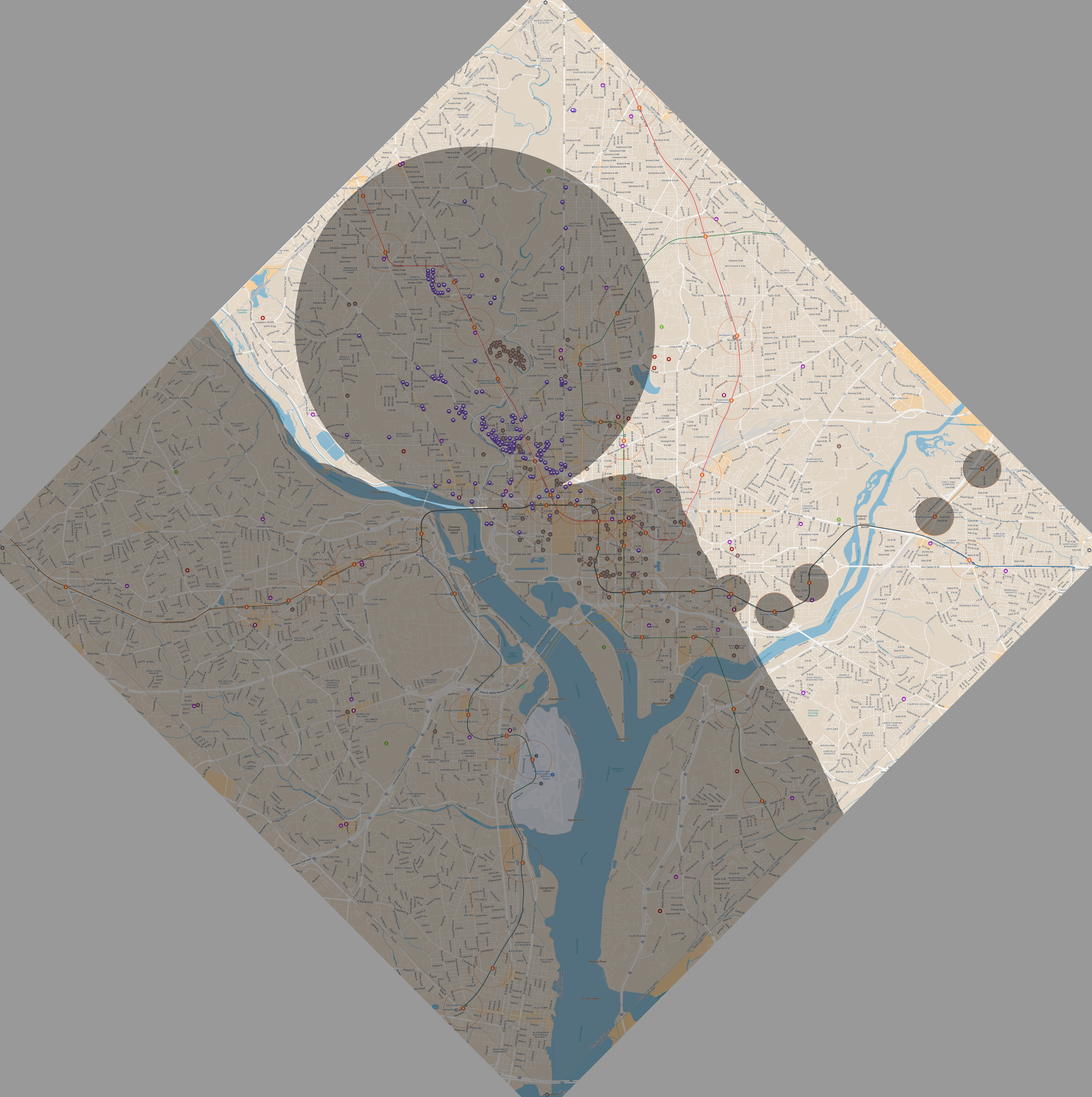
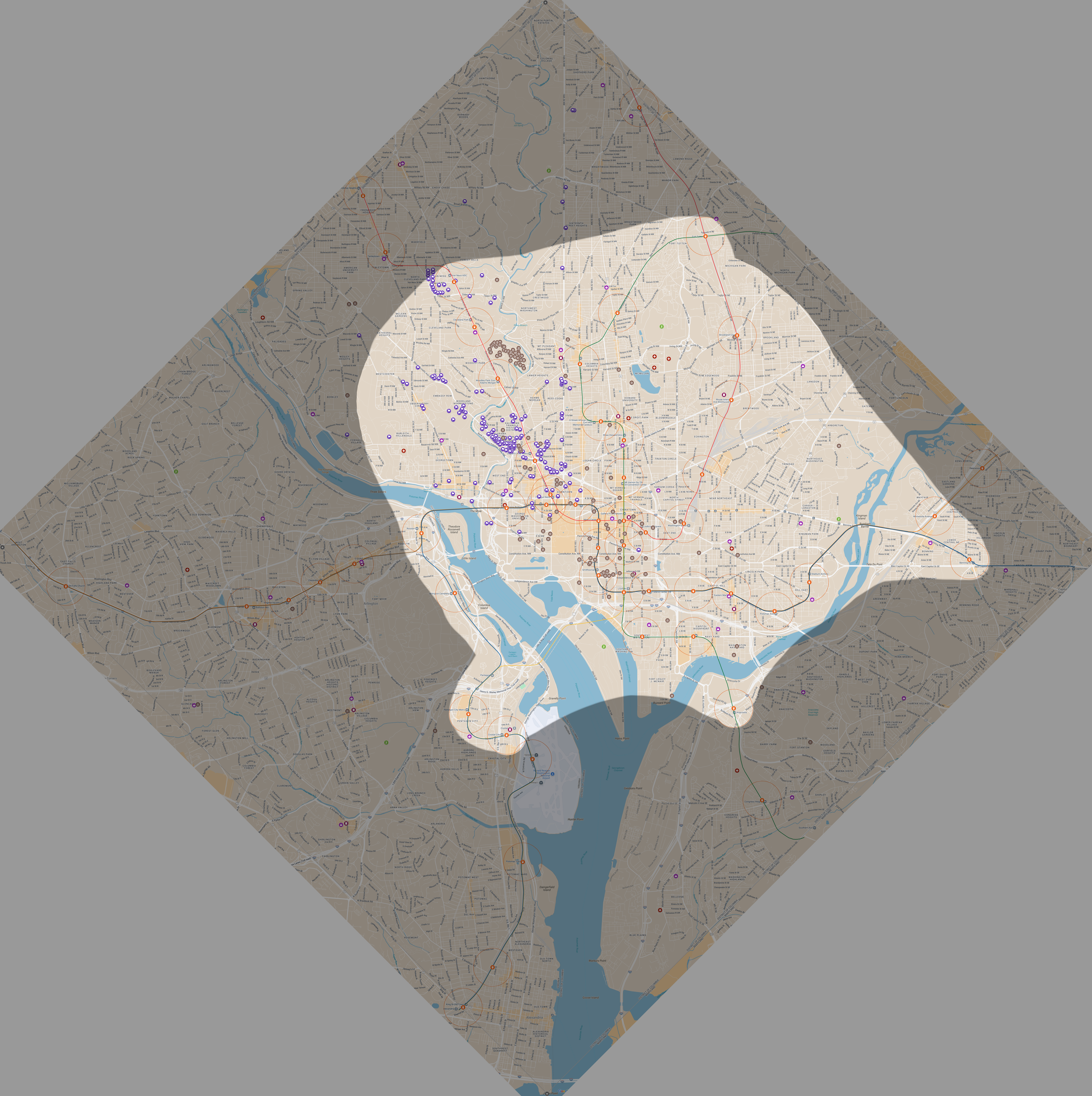
Our play area was the square formed by the original DC boundaries, encompassing all of DC as well as the portion that was retroceded to Virginia (Arlington and a portion of Alexandria). This sizing put us at a ‘small’ game size with Metrorail stations as our transit stations and hiding zones. We did allow both hiders and seekers to use buses and microtransit (bikes and scooters and the like) to get around. Pentagon station was also removed.
This time, to reduce ambiguity, I created a seeker question reference providing some clarifications on certain questions, as well as marking a handful of redundant ones (like Measuring questions with only 1 option). We also decided that hiders being able to take photos ahead of time is kind of lame and it’s strategically interesting to use a photo question to flush hiders from a hiding spot, so we struck that rule. I also found this spreadsheet on r/JetLagTheGame that transcribes curse card text and hider deck distribution, which was useful for seekers to have.
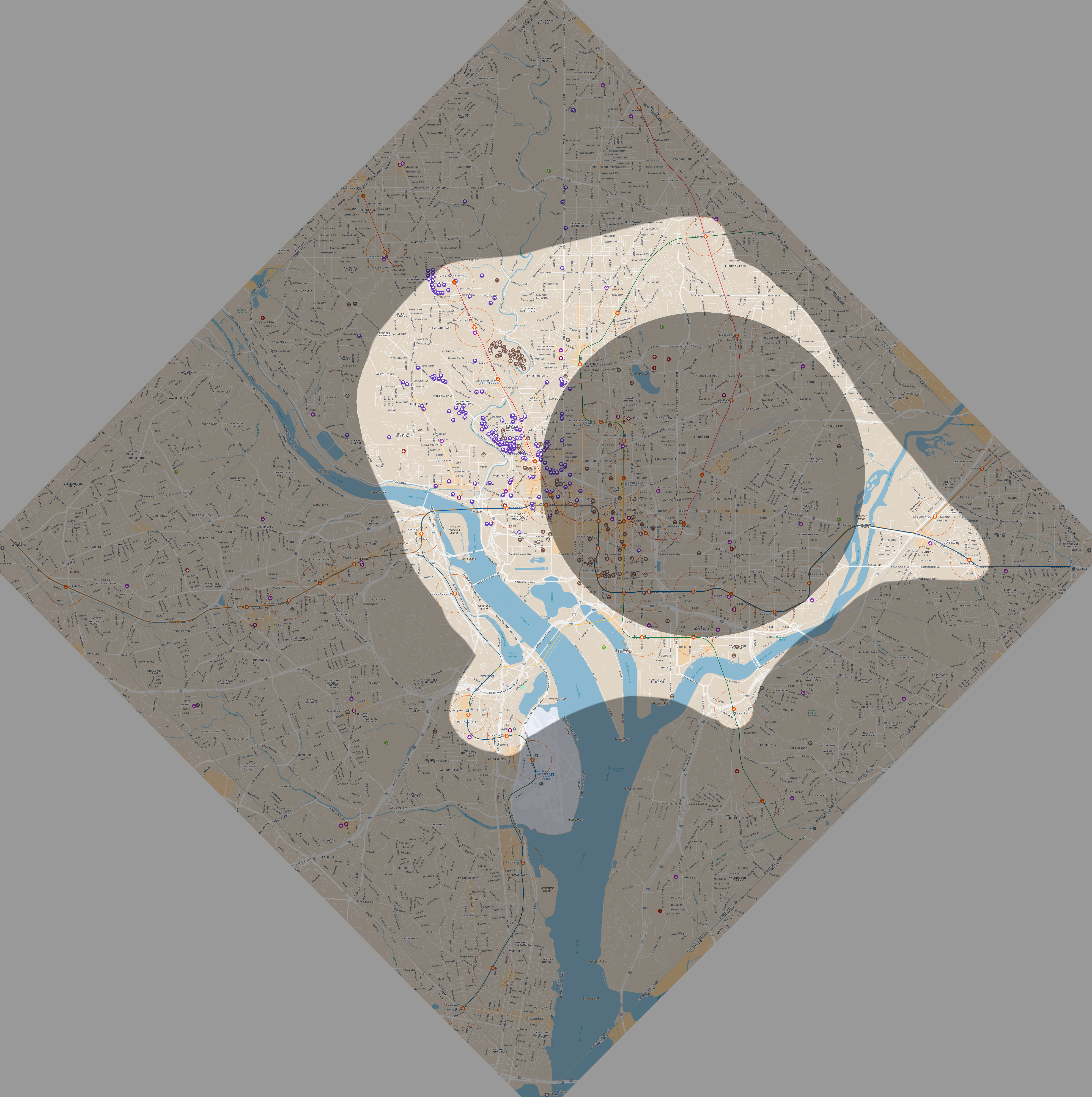
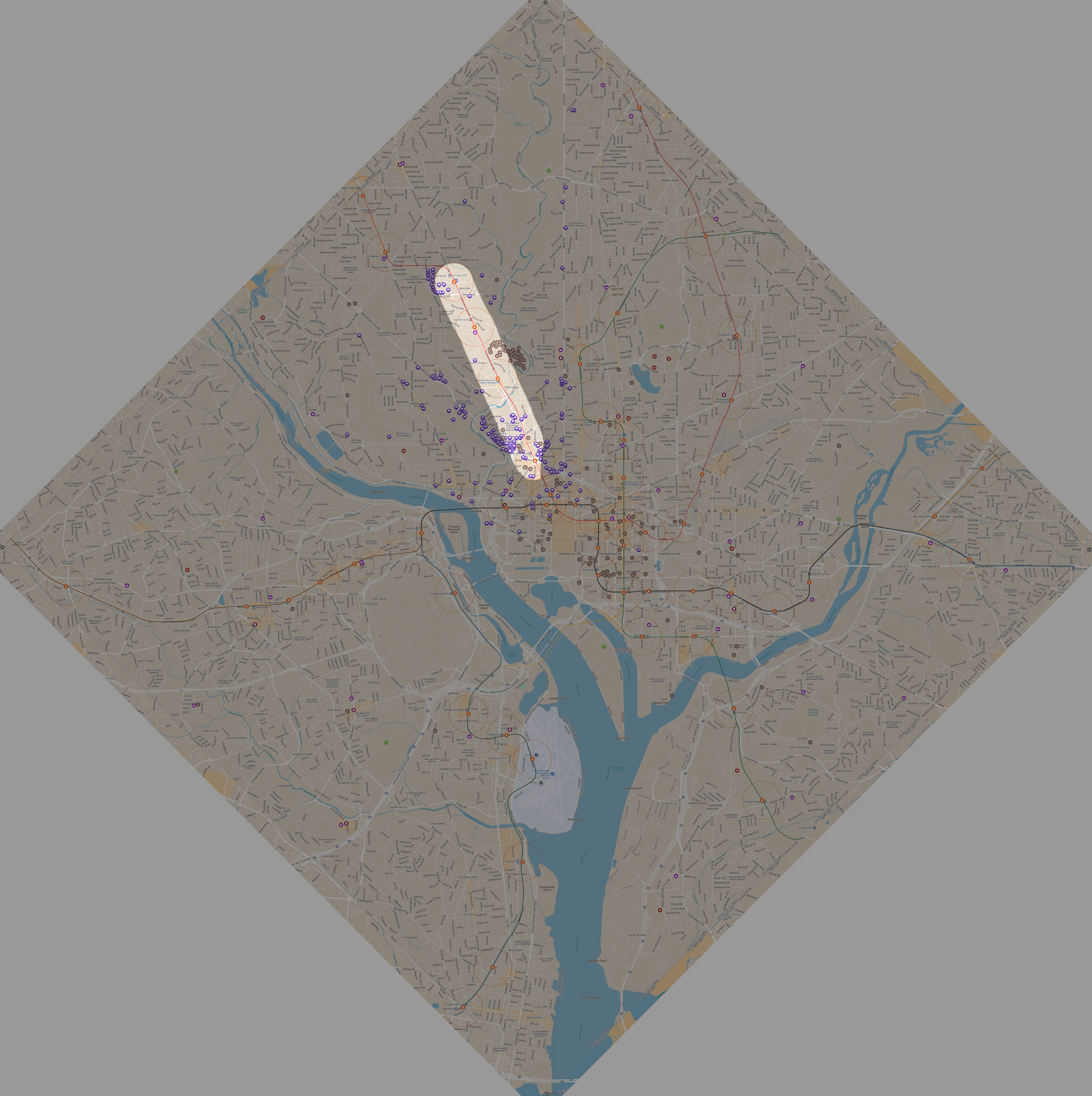
This time I integrated most of the POIs for matching and measuring questions into the map itself to reduce ambiguity (they’re configured as separate layers on the map embedded above and hidden by default, you can toggle them on via sidebar), largely pulling from Open Data DC and filling in Virginia manually. The only ones not included being parks (too many and no premade KML I could find) and things like zoos and airports where there was only one option.
For convenience, I also stitched together screenshots into a higher res image to print off, and this time I remembered to actually add a usable distance reference. There’s also an inset since the POIs make the center area somewhat hard to read. I got these printed off on 11 x 17 in paper at FedEx with the work discount :) feel free to use the MyMaps or below image if you like, and I’m happy to email you the .kra if you want as well. I know there’s a lovely map generator available, but I think analog is more fun especially with a smaller game, especially since I get to break out my drafting compass.
There were 8 of us for the day, so we split into two teams of 4—any more than two teams and it just takes too much time (and, spoiler, we actually cut it slightly short for this game), and I think about 3 people per team is a sweet spot, though next time we get 8-9 people I’d like to try the multiple seeker teams variant. There was one station closure at NoMa, with shuttles running to replace the trains.
Our starting location was… well, it was going to be Metro Center but due to me forgetting to actually bring the game box and needing to go home to pick it up unforeseen issues we actually ended up starting at Clarendon. The plan was to extend the hiding period to 35 minutes (from the default of 30) but given the non central start we put it to 40m instead and I think this was a good choice
Round 1
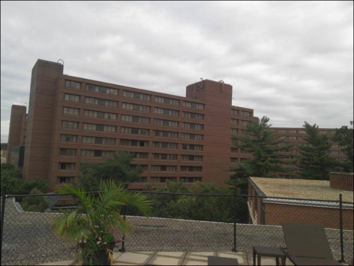
I was on the first hiding team, and we began our 40m hiding period at 11:40. We had a few ideas, though ended up deciding to head to somewhere on the red line. Since we were leaning on the west half we decided to get off at Farragut West and walk to Farragut North instead of transferring to Metro Center, but while we were waiting for the train we thought it might be too easy to bisect that portion of the red line. We noticed that if we took the next train to Union Station and just ran instead of worrying about the shuttle, we could make it into the NoMa circle and decided to go for it. We just barely made it in as the clock ticked over to 12:40
The seekers led with Matching - 1st Level Admin (State) while they were in Virginia, which returned a no on our part and drew us a Draw 1 Expand 1 which we cycled into a Curse of the Luxury Car. We spent awhile scouting out car options and the zone (trying to figure out what our station building and widest street photo points would be). Honestly the car options were kinda sparse around NoMa, where are the embassies when you need them?
While we were doing that, their second question was a Matching - Transit Line at 12:38 while they were on the Orange headed east (so, if their train would stop at our station.) I forget exactly where they were when they asked but it didn’t really matter since the answer was no regardless, eliminating the BOS trunk. Shortly after they followed up with a Matching - Golf Course with their nearest golf course being East Potomac. This also returns a no, Old Soldiers’ and Langston are both closer by a hair (we checked to see if we could run to the southern portion of our zone to make it a yes, but no dice)
 |
|---|
| please keep in mind that these sketches are all recreations I’m making after the fact in Krita, not very precisely, but it should get the gist across. I don’t know exactly what the seekers understood to be their remaining options since I wasn’t on their team at the time, and we as hiders were a bit lazy and not sketching it too closely either |
At 12:57 we decide we don’t have too many car options and kind of want to get food. They still look like they’re at Metro Center and need another question to decide where to go, so we run out the Curse of the Luxury Car with what we think is a 2020 Lincoln Aviator (MSRP $52,195) just to stall for a bit. They answer almost immediately with a BMW X6 xDrive40i (MSRP ~70k+) at 13:04, but hopefully we make them spend about 15 minutes getting out and back into the station. Of course, not five minutes later we see a more expensive BMW SUV ourselves.
While we share a lovely Peruvian chicken for lunch, at 13:20 they ask us a Measuring - Rail Station, saying that they’re at Farragut North and asking if we’re closer or further from Cleveland Park. We didn’t catch this at the time, but this isn’t how the question works—it’s compared to any rail station, not a specific one—but either way we answer no, which pretty much narrows it down to the eastern Red Line stations. At some point here we pick up a veto, and are thinking we just veto the next question on principle
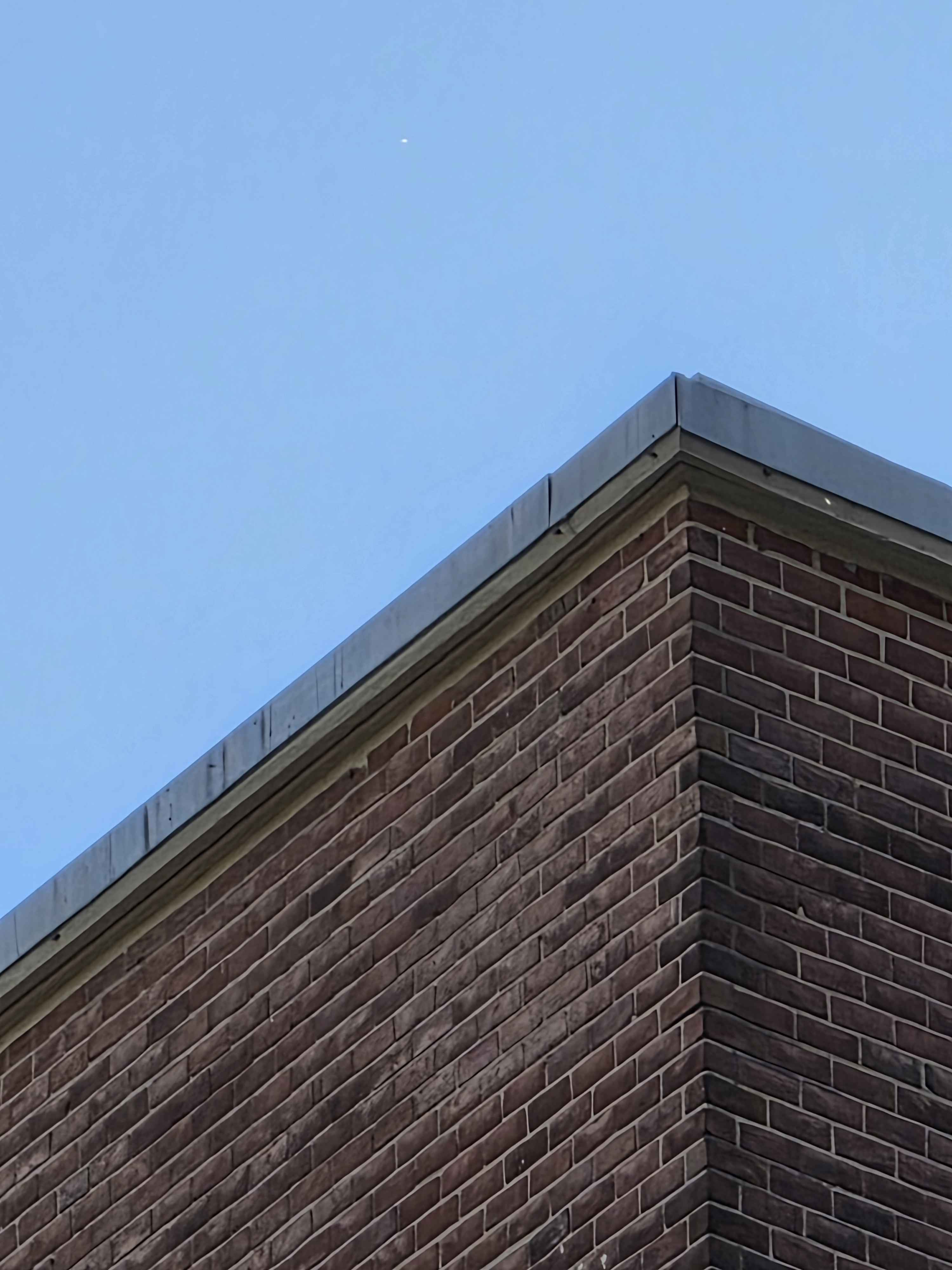
They follow up with a Photo - Tallest Building in Sightline at 13:37 which we discuss vetoing, but ultimately think we can get a pretty nondescript building. There’s a few good options outside of Union Market where we were eating but we settle for this one, which we hope is reasonably hard to identify and isn’t architecturally instinct. The other options we considered all had more striking dark bricks or patterns, we felt. At this point I believe we draw a Duplicate, which makes our line pretty obvious, just dupe the Veto and veto their next two questions
At 13:45 they start a 1/2 mile Thermometer from Chinatown heading north to Mt Vernon Square, presumably trying to narrow down the red line stations, which we of course veto. From what we can tell they continue on and stop at Shaw-Howard U to figure out their next move. After a little bit longer we see them start moving out of Shaw, and from later discussion it turns out they found a bus line that ran from Shaw to NoMa.
As soon as their bus enters Ward 5 at 14:14, they hit us with a Matching - 4th Level Admin (Ward). Now, NoMa’s hiding zone is actually split between Ward 5 and Ward 6, we were sitting in 6 but after some frantic discussion decide that maybe we can confuse them if we answer no, so we sprint towards the border of Ward 5, get in our ‘yes’ answer right at the 5 minute mark, and then get back into Ward 6.
At which point we realize they have just entered our hiding zone and triggered endgame. This… was maybe a mistake? We didn’t realize they had narrowed it down to just the eastern Red line stations and maybe a ‘no’ or just a veto would have been better, although Ward 5 does implicate Rhode Island and further north stations, and the argument was to save the veto for incriminating photo questions in endgame. Thankfully, our luck drew us a second duplicate question lol, since we were kind of just out in the open on some benches, albeit on a quieter side street and out of view of Florida Ave, which formed the border between wards.
After walking around for awhile in the Ward 5 area of NoMa, they ask a Photo - You at 14:42 which we use our duplicated Veto on, then a 1/4 mile Radar from the northern edge of the NoMa zone at 14:48 which we use our Veto on. After that we realize they’ve actually walked outside of the zone (they needed to use a bathroom and just didn’t notice), and we take the opportunity to move back into the Ward 5 area into a food hall we had scouted and thought they had already looked through based on GPS
Well… that was a mistake. We should’ve just stayed in Ward 6 but moved into an indoor area, and it turns out they didn’t actually search that place yet. At 15:07 they ask Photo - You (incurring double from the re-ask penalty).
We draw some card selection and time bonuses and while we’re cycling through the deck to try and get higher time bonuses… they find us. Turns out one of them saw the concrete wall and had a pretty good guess where concrete pillars might be, and they find us just a few minutes later at 15:12
Final time for our team is 2h48m with +26m of time bonuses for a total of 3h14m
The seekers had gotten lunch during the 40m hiding period, but we could use a break, so we all grab some ice cream before setting up for Round 2
Round 2
We start at 15:48 at the nearby ice cream shop in NoMa, and the hiders are off. We take the next 40 minutes to discuss our question strategy and work out their range given NoMa being out of service, figuring they might be able to make it to Rosslyn or Crystal City, but probably not further into Virginia, and that they might’ve been able to get to Anacostia or Minnesota Ave but were kind of unlikely to. We also figure that the northernmost bits of the Red and Green/Yellow are unlikely, and decide that Van Ness and Fort Totten are about the upper limits
We figure that while the Virginia and River East portions are technically possible, it would require pretty tight timing on busses that we’re not sure they were able to catch, and were options that became pretty obvious with a Matching Landmass question which has become a fairly common opener within this and the previous game. So instead, at 16:28, we decide to lead off with a Photo - Building Visible from Station and head towards Union Station, intended to ask a 3 mile radar there while they answer the photo. Unfortunately we just miss the shuttle at NoMa and while waiting for the next one, we get out answer
Even with it being clearly zoomed in quite a bit, we don’t think this looks super urban and soft rule out downtown DC, making the assumption that this is likely to be on one of the Red or northern Green/Yellow. As our bus arrives at 16:46 we make the snap decision to fire off our 2 mile (Custom) Radar from NoMa station, figuring that this can eliminate most of the downtown stations for certain and also chop off the more likely stations on the eastern branch of the Red, leaving only Fort Totten as a low-probability option there. Before we get off on the shuttle we get the answer back as “No”, and so ensues some frantic sketching on a moving bus on my part to figure out our options.
We get off at Union Station and figure we need to eliminate a few of the outlying stations like Columbia Heights and Fort Totten so we don’t burn a bunch of time backtracking. After some debate over whether a thermometer or radar or other Measuring question is more appropriate, our train is here and at 17:14 we settle on a Matching - Transit Line headed west from Union Station towards Shady Grove on the Red Line, which returns a “Yes”. Pretty much the best case scenario, this eliminates everything but a handful of stations. Given the photo question too, we guess that they are in one of: Woodley Park, Cleveland Park, Van Ness, and maybe Dupont
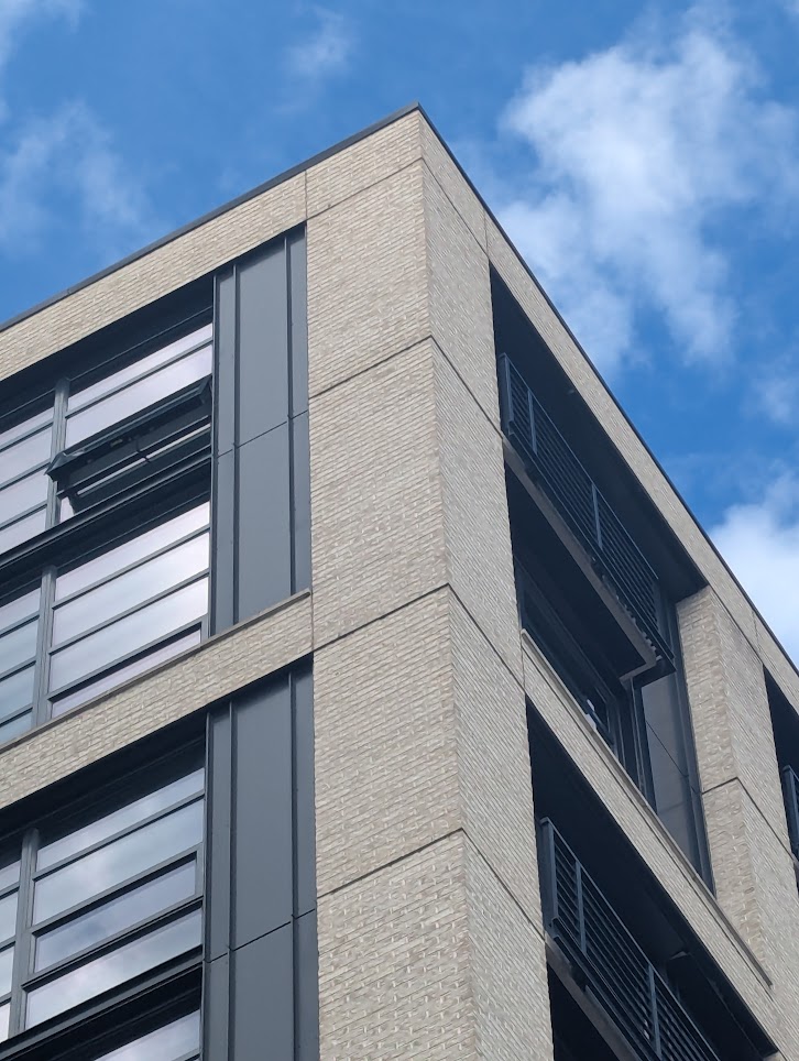
The train is pretty crowded and we’re spread across seats so we can’t discuss much for a good portion of the ride, though myself and another sitting together spend some time looking through station photos and satellite view to try and narrow down the roof. We think Dupont is unlikely (too urban) but possible but the rest all have the levels of medium built-up-ness to have this kind of roof, and she posits that they probably didn’t go that far up just because of the hiding time crunch and the fact that they probably are tired and want to be closer to home. She’s looking through the photos attached to Woodley Park station and finds a few promising ones, and after I spend a few minutes of screwing around on satellite view and looking through all the high rise apartments I find a very promising option
|  |
|  |
| :——————————————————————-: | ——————————————————————— |
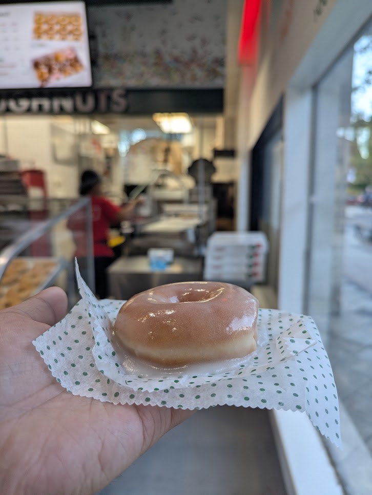
It’s got the right color of brick and that definitely looks like a metal top covering concrete. Still, it’s not 100%, so we decide to get off at Dupont to double check our options and if we don’t see anything promising we head up to Woodley Park and ask some question to confirm. We want to stop by a bathroom anyways. However, after checking out both entrances and confirming that there’s no likely building option, we see the ‘Hot Now’ sign lit on a nearby Krispy Kreme. We have to go, of course
|
| :——————————————————————-: | ——————————————————————— |
It’s got the right color of brick and that definitely looks like a metal top covering concrete. Still, it’s not 100%, so we decide to get off at Dupont to double check our options and if we don’t see anything promising we head up to Woodley Park and ask some question to confirm. We want to stop by a bathroom anyways. However, after checking out both entrances and confirming that there’s no likely building option, we see the ‘Hot Now’ sign lit on a nearby Krispy Kreme. We have to go, of course
 |
|---|
| worth it |
That diversion aside (oh my god it was so good), we proceed onwards to Woodley Park and, once in the zone, drop a Photo - You question at 18:06. While we wait for them to answer, we decide to head south on Connecticut to set up for a 1/2 mile thermometer
We get the photo back and start up a 1/2 mile Thermometer, but instead of heading back north we decide to loop around to check this park area and Rock Creek Trail. We don’t realize until getting closer though that not only does the trail not loop back up with Connecticut, but also that it crosses out of the zone for a little bit near the head. They could have cut cross-country a bit to get onto it, but the lighting and angle of the selfie was such that we thought that wasn’t too likely. To be honest, the thermometer was a mistake on our part. Once we got the selfie we should have fired off a radar or asked for another question, like Tree (which we eventually ask later)
The sun is setting as we trek up Cathedral Ave to finish our thermometer, and the hiders let us know that they’re considering calling it. We have similar thoughts and by the time we get back to the northern end of Connecticut and 1/2 mile from our starting point it’s pretty much fully dark, so once we get back “Colder” from our thermometer we decide to fire off Photo - Tree at 18:40 and walk back south to check some of the trees by the apartments south of the center point.
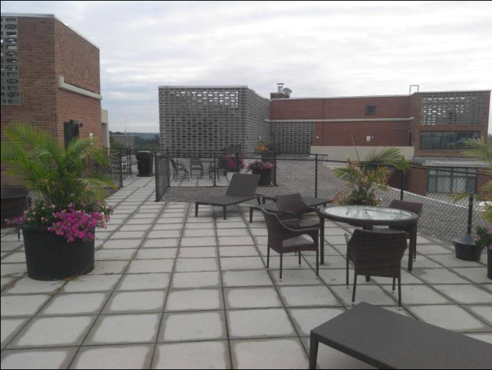
They send their tree photo at 18:47 and call it, we make a final guess at their general location (wrong) and we all meet back up at the metro station to debrief. Turns out they were chilling in the courtyard of a nearby hotel, the Omni. A really nice looking one too, with comfy couches and giant Jenga and a ton of trees.
As an interesting aside, they actually took a bus directly from NoMa to Woodley Park, barely making it in time. We had thought they would have bussed to Green/Yellow or shuttled to Union Station and metroed the rest of the way, but they got lucky with when their hiding period time and it meant they got to dodge the crowded trains and any worries about making transfers.
Their total hiding time was 2h19m plus 18 minutes in time bonuses for a total of 2h37m. They also have a veto in hand and we would have needed to ask at least 1-2 more questions, so whether we could have found them in under 37 minutes is anyone’s guess. It’s a little unfortunate that we had to call it, but everyone was tired and not enjoying the idea of stumbling around in the dark. We had a blast either way, and we finished the day off with a lovely dinner at a nearby Chinese place before splitting up and heading back home
Wrapup
Overall, I think the effort I put into updating the map with common POIs was worth it, makes it way less likely we run into an issue like we did first time where one team saw a golf course and the other team didn’t. I’d like to maybe get the wards in there too since finding a good map for that was surprisingly annoying, but MyMaps actually won’t let me add any more layers. Maybe I’ll put them in the same layer as the boundaries? And also change the ‘Game Area’ polygon to just lines so it doesn’t overlap in a horrid way.
Similarly, creating clarifications/FAQs about the seeker questions was a useful reference. I’m really happy with my map and think for future games I’m happy to just reuse it. The printout is a little clunky but it’s definitely in good enough range—maybe I’ll extend my ruler out up to 3 miles, but that’s about all the changes I really want to make. I don’t think we had any disagreements or confusion about questions this run.
I still never transcribed the rulebook for easier searching, but the combination of the seeker question reference and the spreadsheet we found with curse text, that was less of a pressing issue this game. I probably will continue to not do it for future games because it worked well enough without it and I’m lazy.
Despite the abrupt shift to Clarendon as a starting point, everything still went smoothly. The 40 minute hiding period went so well that I’m considering using it again instead of the 35 minutes we were originally planning on, especially if there are any station closures. It definitely made the bus more viable, with the second team using one to cut across from Shaw to NoMa faster than it would have taken to metro with the transfers. The argument against would be that it makes it hard to eliminate many (if any) stations off the bat based on hider start, but given we start in Metro Center and almost every station is reachable from there within ~30-35m, so maybe that’s for the better anyways?
The stuff we talked about on limiting curse effects (we decided on “2 player’s worth” as the cap, so if a team of 4 got hit by Lemon Phylactery they would only have to buy two lemons), but it never came up. In fact, we drew very few curses overall on both teams, with our team only using the one and the second team never getting a curse they could/wanted to use at all. Not sure what implications that has, but worth pointing out. It makes sense given the deck size though. For our next game I might also look into adding some DC-themed custom curses for extra fun.
Time was even more of an issue than last time, partly because of our later start time due to my fuck up and partly because of the earlier sunset time for being later in the year. I’m still considering splitting it into two days, but that’s just way more time commitment, so I think we may just encourage teams to try and get food/snacks while they’re hiding so we can minimize lunch break time and just try starting a bit earlier. For similar reasons, I may be removing the ‘Move’ powerup from the hider deck just to avoid that potential.
I tried the suggestion of prioritizing 4G/LTE over 5G on the tracker phones and that seemed to help. We still doubled up on Android and iOS (on different cell networks as well) just to be sure, and that definitely helped. I think as a convention seekers should announce via our game chat when they enter a given station’s hiding zone if they believe it may be relevant, though it will be up to them if they want to ‘leak’ that small bit of information.
Overall, we had a blast, even if people were a bit tuckered out at the end. I’m definitely going to run another one of these, and maybe we can wrangle enough people to try the two-seekers variant or some other variant. I spent a bit of time figuring out how to add Georgetown in but decided (and the others agreed) that it just wasn’t really worth it.
If you have any questions about the details or want the files for any of my maps and layers and such, just shoot me an email, I’m happy to chat :)